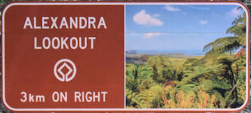
Alexandra Lookout is at the peak of the winding climb up Mount Alexandra on Cape Tribulation Rd.
Located around 7.5km after crossing the Daintree River on the Ferry, the lookout is when you feel you have truly reached the Daintree Rainforest.
Snapper Island and the mouth of the Daintree River can clearly be seen, even though it was a dull and overcast day.
We managed glimpses of the Low Isles, Double Island, and Port Douglas at times, but it would be better on a clear day.

Mount Alexandra was named by the explorer George Dalrymple in 1873. He chose the name after King Edward VII’s wife, Princess Alexandra of Denmark.
The Aboriginal name of Alexandra Lookout is Walu Wugirriga (pronounced wah-lu oo-gid-ee-gah), which means ‘look about’.
There is plenty of parking considering there are no other facilities there. It is a place to take in where you are going (or leaving) rather than somewhere to spend time.
The Daintree Rainforest and Cape Tribulation is towards the end of the Great Barrier Reef Tourist Drive. Alexandra Lookout is the beginning of that end.
As with a lot of lookouts, the vegetation has grown above the line of view for the lookout. The panorama photo shown above had to be taken from different spots and merged together.
To Get There

From the Daintree Discovery Centre, follow Tulip Oak Rd to Cape Tribulation Rd and turn left. Follow Cape Tribulation Rd for 1.9km and Alexandra Lookout will be on the left.
From the Daintree Ferry, follow Cape Tribulation Rd for 7.5km and Alexandra Lookout will be on the right. A brown sign is 3km before reaching the lookout with another brown sign just before the entrance.


