


Kalbarri National Park in Western Australia is on the Coral Coast region at the lower reaches of the Murchison River.
The Kalbarri National Park inland gorge ![]() locations are accessed only during the day and require a vehicle permit. They are mainly of the Murchison River Gorge with lookouts, scenic views and walks.
locations are accessed only during the day and require a vehicle permit. They are mainly of the Murchison River Gorge with lookouts, scenic views and walks.
Coastal Locations
Unlike the inland gorge locations, the coastal locations of Kalbarri National Park do not require a vehicle permit to access. While still part of the Kalbarri National Park, they are accessed along the road following the coast.
Red Bluff
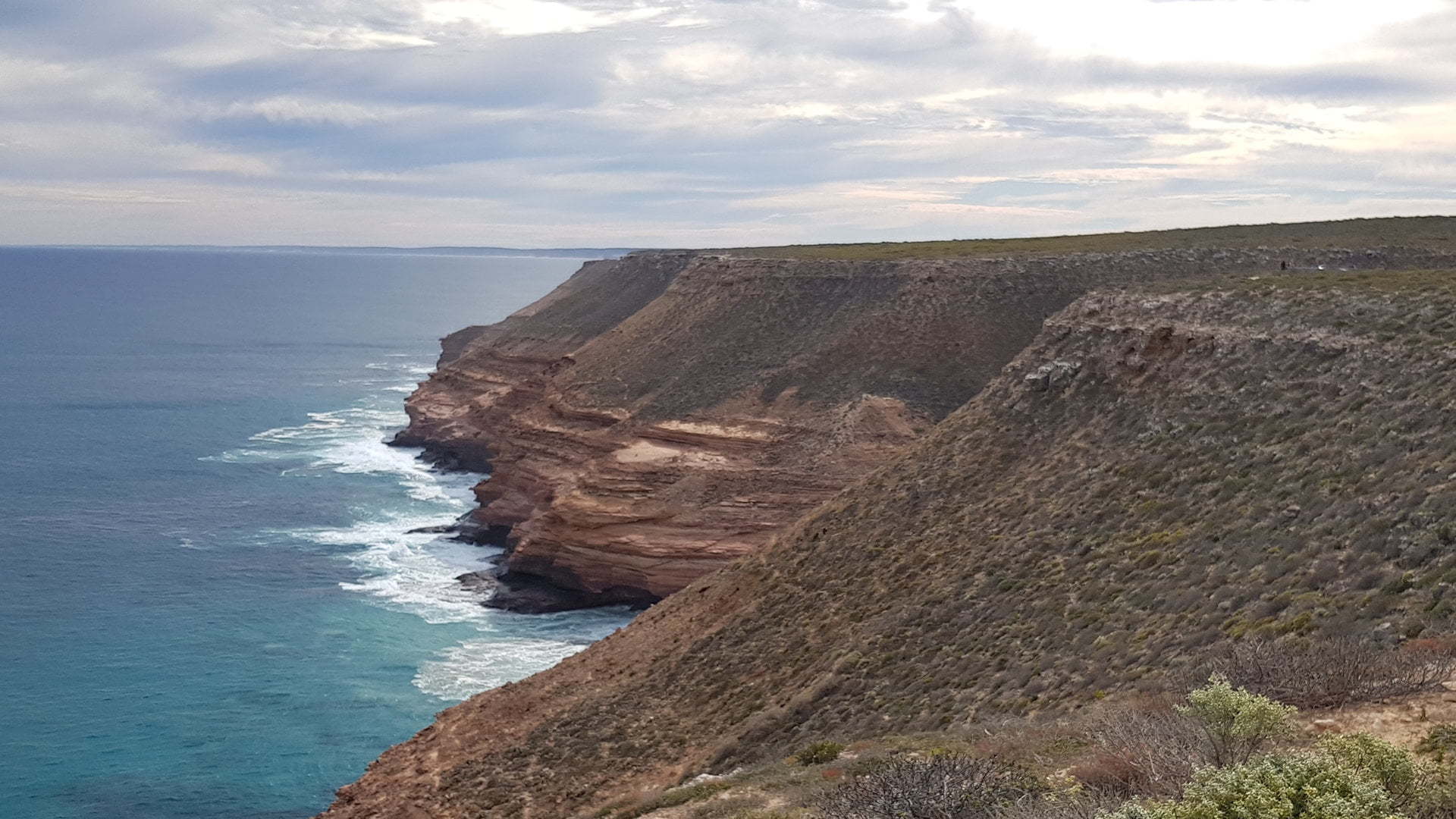
Red Bluff ![]() is a coastal lookout with views to Jakes Point, the Murchison River mouth, and Meanarra Hill. Nearby Wittlecarra Creek is believed to the first permanent landing of Europeans in Australia, in 1629.
is a coastal lookout with views to Jakes Point, the Murchison River mouth, and Meanarra Hill. Nearby Wittlecarra Creek is believed to the first permanent landing of Europeans in Australia, in 1629.
The Red Bluff lookout walk is 1km return with a wheelchair accessible lookout just before it at 700m return.
The Bluff to Beach Trail leads down to the beach. It is about 2km return from the car park.
Mushroom Rock
Mushroom Rock ![]() is a viewpoint where you can see how wind and water have created the formations in the sandstone cliffs.
is a viewpoint where you can see how wind and water have created the formations in the sandstone cliffs.
The Rainbow Valley Trail is a 3km loop taking up to 2 hours. The loop is from the Rainbow Valley car park and has a coastal path and a more sheltered valley path, either of which can be taken as a return path instead of the loop.
Rainbow Valley
Unique coastal features and compacted layers of minerals, sands and silts to form a rainbow of colours in the stone. Rainbows may also be seen in the sea mist.
Eagle Gorge
Eagle Gorge lookout and the beach are accessed from the Eagle Gorge car park. Eagle Gorge Beach is a grade 3 one kilometre return walk with short and steep switchback over sandstone terraces.
The Bigurda Trail is accessed from Eagle Gorge, an 8-kilometre trail hugging the coastline through to Natural Bridge. The walk takes up to 5 hours one way, so transport should be arranged for the start or end of the trail.
Grandstand and Shellhouse
Grandstand ![]() has a layered and stepped cliff down to the Indian Ocean in front of it. From Grandstand is a short 300m walk to Shellhouse with a viewing platform.
has a layered and stepped cliff down to the Indian Ocean in front of it. From Grandstand is a short 300m walk to Shellhouse with a viewing platform.
Island Rock
Island Rock ![]() was part of the shoreline but after erosion, it has become a solitary ‘sea stack’ A viewing platform provides views of the rock formation and is only a short walk from the carpark. Alternatively, a short boardwalk from Natural Bridge leads to Island Rock.
was part of the shoreline but after erosion, it has become a solitary ‘sea stack’ A viewing platform provides views of the rock formation and is only a short walk from the carpark. Alternatively, a short boardwalk from Natural Bridge leads to Island Rock.
Natural Bridge
Natural Bridge ![]() is a rock formation, similar to Island Rock except it has a connected arch between it and the shoreline. The views take in the rest of the decaying cliff rock formations.
is a rock formation, similar to Island Rock except it has a connected arch between it and the shoreline. The views take in the rest of the decaying cliff rock formations.
Natural Bridge has a wheelchair accessible picnic area with toilets. A boardwalk from Natural Bridge leads to Island Rock, 1.2km return.
Eagle Gorge
View Eagle Gorge ![]() and along the coastline of Kalbarri National Park from the lookout.
and along the coastline of Kalbarri National Park from the lookout.
Pot Alley
Pot Alley ![]() is a gorge with an accessible beach. There is a 10 to 15 minute walk from the parking area through the end of the gorge to the beach.
is a gorge with an accessible beach. There is a 10 to 15 minute walk from the parking area through the end of the gorge to the beach.
Bigurda Trail
The longer 8km Bigurda Trail from Natural Bridge heads to Eagle Gorge. 8km is one way, so it is best to arrange transport to or from the other end.
The trail follows along the tops of the coastline, passing Natural Bridge, Island Rock, Grandstand, Shellhouse, and Eagle Gorge.
| From/To | Natural Bridge | Island Rock | Grandstand | Shellhouse | Eagle Gorge |
| Natural Bridge | 800m | 3.4km | 3.7km | 8.0km | |
| Island Rock | 800m | 2.6km | 2.9km | 7.2km | |
| Grandstand | 3.4km | 2.6km | 300m | 4.6km | |
| Shellhouse | 3.7km | 2.9km | 300m | 4.3km | |
| Eagle Gorge | 8.0km | 7.2km | 4.6km | 4.3km |
To get there:

From Kalbarri township, head south along Grey St which starts heading west. It bends to the left and becomes Red Bluff Rd. The Kalbarri National Park Coastal Cliffs locations are along the next 10 or more kilometres with several detours off the main road.
From Northampton (north of Geraldton), head north on North West Coastal Hwy for about 47km and turn into Anjana-Kalbarri Rd. Follow Anjana-Kalbarri Rd for 64.7km, driving into the Kalbarri township. Turn left into Grey St and follow the road which becomes Red Bluff Rd after a left bend. The Kalbarri National Park Coastal Cliffs locations are along the next 10 or more kilometres with several detours off the main road.
From Carnarvon, head south on North West Coastal Hwy for about 370km and turn right into Anjana-Kalbarri Rd. Follow Anjana-Kalbarri Rd for 71km, driving into the Kalbarri township. Turn left into Grey St and follow the road which becomes Red Bluff Rd after a left bend. The Kalbarri National Park Coastal Cliffs locations is along the next 10 or more kilometres with several detours off the main road.
