Mount Glorious is a popular destination for Brisbane residents, close to the city yet you feel like you are a world away.
Maiala National Park was first formed in 1940, with sections set aside since 1901. The first walking track started in 1946 using unemployed men after the war to build tracks.
The Rainforest Circuit was Queensland’s first self-guided walking trail in 1965, in addition to the Cypress Grove and Greene’s Falls walks already established.

Jollys Lookout National Park, Boombana National Park, and Manorina National Park were combined with Maiala National Park together with parcels of state forest land to form the D’Aguilar National Park.
The picnic area was an area cleared for cattle grazing and a steam-powered sawmill was build in the 1910s. Timber was sought in the area from the 1870s in search of red cedars, hoop pines, and other quality timbers. Nearby Red Cedar Park ![]() west of Maiala is named after the red cedar timber industry in the area.
west of Maiala is named after the red cedar timber industry in the area.
The picnic area has a lot of open grass area with a few picnic tables scattered around. The grass is mostly on a sloped hillside but is still suitable for throwing out a picnic rug. Flushing toilets provide the necessary facilities to be able to spend the whole day at Maiala.
Maiala means “quiet place” in the local Aboriginal language, something that would have been inaccurate during the timber industry days but is very fitting today in the quiet rainforest surroundings.

Quiet observation rewards with sightings of various wildlife. Lizards are found in glimpses of sunlight, sunning themselves in the warmth. Birds flutter by catching insects disturbed by walking along the trails and grass in the picnic area.
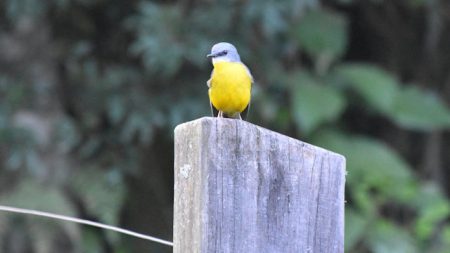
We were delighted with some Eastern Yellow Robins while we were resting after our return walk to Greenes Falls. They kept their distance from us but were close enough to enjoy the bright yellow chest as they perched on fence posts and the tree above us.
Most of D’Aguilar National Park is open eucalypt forests. There are some patches of subtropical rainforests, represented at Maiala and can be experienced along the walks.
Rainforest Circuit

Queensland’s first self-guided walking track, the Rainforest Circuit has been open since 1965. The circuit is a 2km grade 3 track. The track is not difficult, however, there are parts with steps and obstacles to go over.
The Rainforest Circuit will take about 1 hour to complete, however, it leads from the picnic area to Greene’s Falls Track and the Cypress Grove Circuit, so you may want to allow extra time to do these walks while you are there.
A Sydney blue gum is a sole survivor of the eucalypt forest that was once dominant in the area.
Greenes Falls Track

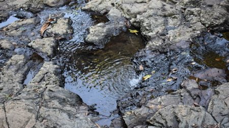
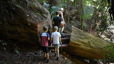
Greens Falls Track detours off the Rainforest Circuit, adding another 2.3km return to the walk. The walk down to the falls is an easy grade 3 with a few steps. There is a large fallen tree across the track in one part. Rather than clear it away, a step-through has been cut into it. At the bottom, there is a viewing platform to observe the waterfall and the water passing along the stream before it.
The return walk is a little more difficult with the stairs needing to be negotiated in the opposite direction – what goes down must come up. The climb back up makes this track tougher but with the beautiful scenery along the way, it doesn’t hurt to stop every now and then to catch your breath if required.
Cypress Grove Track
The Cypress Grove Track is a short branch from the Greenes Falls Track, adding an additional 500m to the overall walk. It is also a grade 3 walk, leading through an area of cypress.
Western Track
The Western Track is across the road from the Maiala Picnic Area with a short walk to the Western Window, a lookout with views to the west towards the Great Dividing Range. This walk is a 1.2km return grade 4 walk, joining with the Westside Track
Westside Track
Westside Track is a 6.4km return grade 4 track, going from Joyners Ridge Road up to Lawton Road. The Western Track from Maiala leads to part-way along Westside Track at the Western Window, which can be used as an access point to return walk part of or both ends of the Westside Track.
Westside Track is a scenic walk through subtropical rainforest, along the steep slopes of the mountains.
To get there:

From Samford, head west on Mount Glorious Dr and follow to the end for 15.6km, the last 5km or so is windy. Turn right into Mt Nebo Rd and follow for 3.2km, with the entrance to Maiala on the right with the brown sign.
From Brisbane Valley Highway below Wivenhoe Dam, turn into Wivenhoe Somerset Rd and follow for 15.3km. Turn right into Mt Nebo Rd and follow for 23.6km, with the entrance to Maiala on the left with the brown sign.
Cost: Free
Hours: Anytime
Toilets: Yes
Bins: No
Tables: Yes
Seating: Yes
Water: No
Food: No
Wheelchair accessible: No
Pets: No
BBQ: No
Playground: No


