
Part of the Great Dividing Range, Goomburra Section provides spectacular walks and views through the rugged mountain area and two camping grounds.
Goomburra Section is the most northern of 4 main locations of the Main Range National Park. The other sections include Queen Mary Falls ![]()
![]() at the southern end and Spicers Gap
at the southern end and Spicers Gap ![]()
![]() and Cunninghams Gap in the middle.
and Cunninghams Gap in the middle.
The name Goomburra is an Aboriginal word indicating one of two possible meanings. “Fire black tribe”, a corruption of the word goone-burra, or “shield”, derived from kurrajong tree.
The two camping grounds are close to each other, Manna Gum Campground about 250m past Poplar Flat Campground. Manna Gum is a little closer to the nearby walks but either is otherwise as good as the other.
The campgrounds have toilets with disabled access, wood BBQs, and non-potable water available. Camping spots are not numbered or designated in any way. They are more or less open fields so just find anywhere in the grounds to set up camp.
I stayed overnight at Manna Gum, after spending the day before at Spicers Gap ![]()
![]() and Governors Chair Lookout
and Governors Chair Lookout ![]()
![]() . This let me wake up and be ready for a walk nice and early, although, the June temperatures of 2 degrees when I woke made for a cooler than I was hoping start for the day.
. This let me wake up and be ready for a walk nice and early, although, the June temperatures of 2 degrees when I woke made for a cooler than I was hoping start for the day.
There are plenty of walks at Goomburra Section of the Main Range National Park to fill the weekend and have little time for rest.
Dalrymple Circuit
Starting at the eastern end of Manna Gum camping area, the Dalrymple Circuit walk is an easy walking track, about 1.2km return.
The Main Range National Park brochure has it rated as a class 2 walk but the website and an information sign on the walk have it rated as a class 3.
Information signs provide information about the area and features along the walk. Boardwalks are built along parts of the walk, making it a great walk for those who don’t want something too hard or have younger children.
A large tree stump is a reminder of the logging history in Goomburra. It is the base of a 36m Sydney Blue Gum Eucalyptus estimated to have been over 500 years old. It was felled in 1962, taking two men half a day to cut it down. Much of the timber was used to build house frames in Brisbane and Ipswich.
Dalrymple Creek runs along a portion of the circuit walk, a headwater for the Condamine River. It runs along a basalt rock face, formed millions of years ago from a lava flow from the Main Range Volcano.

Cascades Circuit
The Cascades Circuit starts halfway around the Dalrymple Circuit. Where the Dalrymple Circuit is an easy walk, Cascades quickly becomes are harder class 4 track.
Walking clockwise, Cascades Circuit continues to follow Dalrymple Creek upstream with a number of cascades along the way. Then returning to the Dalrymple Circuit for a 6.5km walk.
The first half, the northern section, is the most difficult with a number of crossings over the creek. Considering how dry it is at most places at the moment with much of Queensland suffering from drought (mid-2018), the creek may normally require getting your feet wet.
While the creek is often rugged it is accessible through parts with plenty to stop and explore the cascades and rock pools.
The last part along the creek has a steep climbing section. There are formed steps but they are narrow and very steep. Dirt and stone have filled the step surfaces making them a little more challenging so care is needed.
After the steep climb, the creek is crossed one more time and the track becomes far easier for the rest of the way and quicker progress is made.
The track either returns to the Dalrymple Circuit or extend the walk by branching off to walk the Ridge Track. Taking the Ridge Track extends the walk to 7.6km and an extra half hour.
Ridge Track
Ridge Track is a hilly open forest circuit track along a ridge above the camping areas. It is a class 4 track with moderate grades for most of the way and some steeper sections where care is needed with loose gravel making it slippery.
The Ridge Track is a circuit from Manna Gum camping area and starts part way along the southern section of the Cascades Circuit track. The southern section of Cascades Circuit is easier and quicker so this is the easiest way to access Ridge Track for a 5km walk.
Walking the northern section of the Cascades Circuit makes it a 7.6km walk, but also adds a lot more time as it is slow progress over the more difficult terrain.
Ridge Track returns along the road between Manna Gum and Poplar Flat camping areas.
North Branch Track
The North Branch Track is a 7km return track starting from opposite the Kurrajong picnic area. It follows the North Branch Creek (north branch of Dalrymple Creek) ranging from open fields through to bush and rainforest.
The creek is crossed several times and may require getting your feet wet, especially after rain.
Araucaria Falls
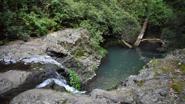
Araucaria Falls is a 3.6km return track, starting from a small parking area along Lookout Road. The walk is predominantly rainforest, finishing reaching the North Branch Creek at the top of the Araucaria Falls. Cross the creek and descend to the deep water pool below the falls.
The name comes from the scientific name of the hoop pine, Araucaria Cunninghamii. The scientific name is in honour of explorer and botanist Allan Cunningham who collected specimens in the 1820s.
Sylvesters Lookout

Sylvester’s Lookout is a short 940m return track leading to stunning views spanning from Mt French, Mt Edwards, Lake Moogerah, Mt Moon and Mt Barney through to the border ranges.
The walk is an easy class 3 walk. The track is uneven and narrow with lots of tree buttress roots coming across it but is safe and easy.
Sylvesters Lookout starts from a small parking area along Lookout Road. There isn’t much warning on approach could be missed if you don’t pay attention to the signs on the side of the road. There is room for only 3 or 4 vehicles which would likely block the signs but vehicles parked will give a good hint of where to stop.
Mt Castle Lookout

Mount Castle Lookout is another short 960m return track. It is uneven and narrow, and climbs upwards all the way which may require a rest stop or two but is otherwise an easy class 3 walk.
The views look out directly over Laidley Valley to the exposed cliffs of Mt Castle. On a clear day the views extend beyond Mt Castle to Brisbane and Mt Coot-tha ![]()
![]() , and Mt Tamborine. Mt French
, and Mt Tamborine. Mt French ![]()
![]() and Mt Edwards are difficult to see with trees obscuring the views, but Mt Walker can be seen clearly.
and Mt Edwards are difficult to see with trees obscuring the views, but Mt Walker can be seen clearly.
Mt Castle Lookout starts at the end of Lookout Road with plenty of room for parking. Winder Track starts from the same location.
Winder Track
The Winder Track is a 12km return class 4 walking track. It heads north following along the eastern crest of the range.
In spite of the track following the ridgeline, there are no views along the Winder Track as the forest is too dense.
The track leads to a Winder, a relic from the timber industry and the namesake of the track. Loggers converted an old truck into a winch to haul up the large logs, and the Winder is what is left.
Winder Track starts at the end of Lookout Road with plenty of parking space.
Kurrajong Picnic Area
Kurrajong Picnic Area is for day use, with picnic tables and wood BBQs provided for use. It was once the site of the timber cutters’ and forestry workers’ camp.
There are picnic tables and wood BBQs available. There are no toilets at Kurrajong Picnic Area but it is a short walk to Poplar Flat camping area where toilets can be used.
At the entry to the picnic area is a sculpture of the Fley’s Barred Frog, an endangered species endemic to the Goomburra Section of the Main Range National Park.
To Get There
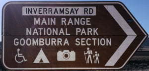
If heading west from Cunninghams Gap, turn right after 21.6km into Goomburra Rd. Continue along Goomburra Rd for 9.8km and turn right into Inverramsay Rd at the brown sign. Follow Invarramsay Rd for 22.4km and continue straight ahead into Forestry Reserve Rd. Poplar Flat Campground is 3km further on.
If heading north from Warwick along New England Hwy, turn right onto Cunningham Hwy towards Brisbane. After 13km turn left into Goomburra Rd. Continue along Goomburra Rd for 9.8km and turn right into Inverramsay Rd at the brown sign. Follow Invarramsay Rd for 22.4km and continue straight ahead into Forestry Reserve Rd. Poplar Flat Campground is 3km further on.
If heading south from Toowoomba along New England Hwy, 2.9km after leaving Allora, turn left into Goomburra Rd. After 10.8km continue straight ahead with brown signs towards Continue along Goomburra Rd for Main Range National Park Goomburra Section. Continue along Goomburra Rd for 9.8km and turn right into Inverramsay Rd at the brown sign. Follow Invarramsay Rd for 22.4km and continue straight ahead into Forestry Reserve Rd. Poplar Flat Campground is 3km further on.
Links
https://parks.des.qld.gov.au/parks/main-range

