
The Main Range National Park Walking Tracks is the main part of the Cunningham’s Gap section of the Main Range National Park. It is between Spicers Gap ![]()
![]() to the south and Goomburra Section
to the south and Goomburra Section ![]()
![]() to the north. Queen Mary Falls
to the north. Queen Mary Falls ![]()
![]() is the fourth section of the Main Range National Park.
is the fourth section of the Main Range National Park.
The walking tracks are mainly class 4 trails with a couple of easier class 3 trails near the parking area, one that heads to the Main Range National Park Picnic Area ![]()
![]() and the other to a lookout over the Fassifern Valley.
and the other to a lookout over the Fassifern Valley.
There is a parking area at the walking tracks with most on the northern side of the highway and a few more parking spots on the side of the highway on the southern side.
There are no facilities at the walking tracks but there are toilets and picnic tables at the Main Range National Park Picnic Area a couple of kilometres west of the walking tracks.
Box Forest Track
Box Forest Track is named after the brush box trees which line the West Gap Creek the walk follows. The 5km return walk leads to the Main Range National Park Picnic Area and is a fairly easy class 3 trail.
Rainforest Circuit
The Rainforest Circuit is the start of most of the walks at Cunningham’s Gap. The circuit leads up to the Fassifern Valley Lookout, the easiest way is to head left at the base of the stairs and after the lookout return by coming down the stairs. Climbing and returning by the stairs is the shortest way to get to the lookout.
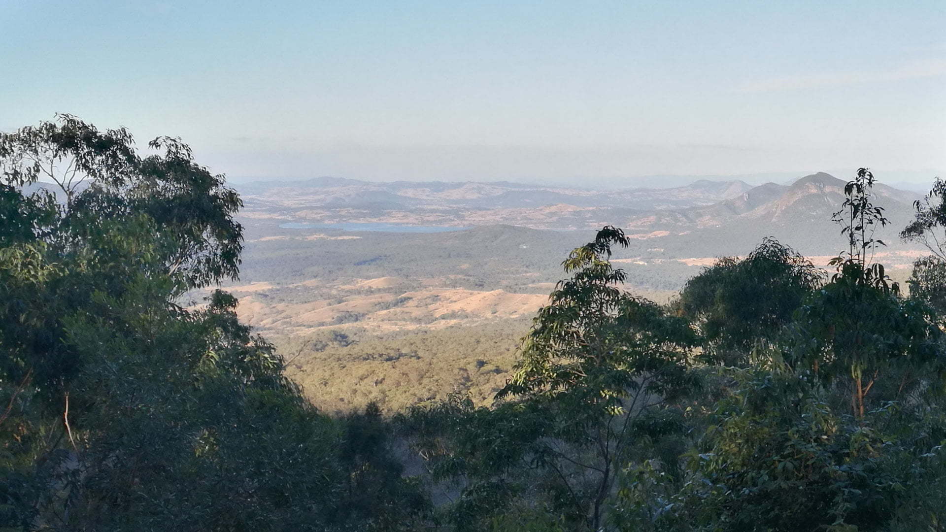
The views from the Fassifern Valley Lookout is to the east off the Main Range mountains. The views are obscured by the trees growing tall in front of the view, so the views are not as spectacular as from Governors Chair Lookout ![]()
![]() at Spicers Gap.
at Spicers Gap.
Mt Edward and Mt French can be seen to the left through to Mt Greville to the right. Mt Moon and Mt Maroon were too obscured to been seen but is shown on an information board at the lookout. Inbetween Lake Moogerah is visible from the view.
Gap Creek Falls, Palm Grove Circuit, Mount Cordeaux, and Bare Rock and Morgans Walk are accessed from the Rainforest Circuit.
Palm Grove Circuit
Palm Grove Circuit is a 4.4km return walk on a class 4 trail, including a 1km circuit at the end. The walk goes through open eucalypt forest and piccabeen palms rainforest.
The walk is fairly easy. There is a part of the track that has a steep side to it so care is needed especially with children. The track can be overgrown at times with vegetation growing across the track.
Palm Grove Circuit starts from the Rainforest Circuit.
Mt Cordeaux Track
The Mount Cordeaux Track is a 6.8km return class 4 trail, starting from the Rainforest Circuit, and continues as a longer walk on the Bare Rock Track.
The walk starts through rainforest before opening up to rocky outcrops. The walk heads north west before doubling back towards a lookout at the southern end of the cliffs.
Care is needed as there are no barriers from the cliff edges.
Bare Rock Track and Morgans Walk
Bare Rock Track continues north from the lookout of the Mount Cordeaux Track, extending the 6.8km return walk to 12.4km return.
The walk re-enters rainforest before coming back out to rocky outcrops with views across the Main Range National Park.
Morgans Walk is a 700m return detour from the track which ends in a grove of montane heath.
Gap Creek Falls Track
Gap Creek Falls starts from near the lookout on the Rainforest Circuit. It is a class 4 walk for 9.8km return to the parking area.
The walk descends the ridge below Mount Cordeaux through open eucalypt forests and ending at the top of the Gap Creek Falls.
The walk is not difficult but the return walk is uphill so it can be very tiring and slow going. Allow 5-6 hours for the walk.
Mt Mitchell Track
Mt Mitchell Track starts from the opposite side of the road from the main parking area. It takes you to the two peaks of Mount Mitchell, first to the west peak then to the east peak with views from a knife-edge ridge.
The class 4 trail takes you 10.2km return through open eucalypt forest and rainforest.
To get there:
 Heading west along Cunningham Hwy, after reaching the top of the Cunningham’s Gap climb, the parking area is immediately on the right with some parking on the left along the road. A brown sign is seen while still climbing Cunningham’s Gap 1km before the parking area.
Heading east along Cunningham Hwy, a service station is passed just before the Main Range National Park and the vegetation closes in nearer to the road. From the service station, continue for another 1.8km and the entrance to the Picnic Area is on the left with a small brown sign with a symbol for a picnic area is opposite. The entrance comes up quickly and is on a left-hand bend. An overtaking lane ends shortly before the entrance. There is not a lot of room on the road so ensure vehicles behind you are aware you are slowing down to turn.
Cost: Free
Hours: Anytime
Toilets: No
Bins: No
Tables: No
Seating: No
Water: No
Food: No
Wheelchair accessible: No
Pets: No
BBQ: No
Playground: No

